Soil Reports and Field Checks for Difficult Planting Sites
Learn what a soil map, laboratory report, field observation, and drainage test can each establish before choosing plants.
On this page
A soil map, laboratory test, field observation, and drainage test answer different questions. Combining them can improve a site record, but none alone tells you which plant will thrive or why a bed stays wet. Start with the decision you need to make, then choose the tool that can answer that question.
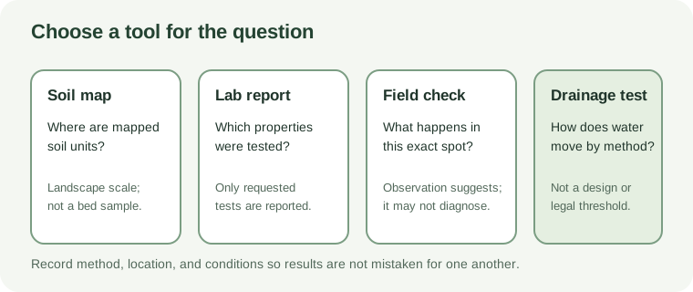
Match the tool to the question
| Tool | Useful for | Important limit |
|---|---|---|
| Soil map | Finding mapped soil units and their landscape descriptions. In the United States, the USDA Web Soil Survey lets you define an area and view mapped information. | A map unit is not a sample from a garden bed and can hide small-scale variation. The USDA tool covers U.S. soil-survey areas, not Ontario. |
| Laboratory report | Describing selected properties such as texture, pH, organic matter, and nutrients; optional tests may address salts or trace elements. | A routine fertility panel is not a complete physical diagnosis or a contaminant screen unless the relevant test is requested. Methods and interpretations vary. |
| Field observation | Recording where water stands, where soil differs, whether traffic is concentrated, and how conditions change with season. | Appearance may suggest a question but cannot by itself distinguish compaction, clay, a shallow layer, a high water table, or a designed drainage system. |
| Drainage or infiltration test | Comparing how a defined location accepts water using a published local method. | Results depend on soil moisture, method, depth, and site conditions. Extension screening ranges are not engineering or regulatory thresholds. |
Prepare a useful laboratory question
Tell the laboratory where the sample came from and what you plan to grow or decide. Follow that laboratory’s instructions for selecting and mixing samples; keep unlike beds or areas separate rather than combining them. Ask which properties are included, what units and methods it uses, and whether the interpretation applies to ornamental or native plantings.
University of Minnesota Extension describes a routine garden test as a snapshot that can include estimated texture, pH, organic matter, phosphorus, and potassium. It also offers optional testing such as soluble salts and lead. These examples show why the test request matters; choose a laboratory and panel appropriate to your location and concern. If unknown fill, former industrial use, roadside exposure, or food production raises a contamination question, seek local advice about the right analytes and how results should be interpreted before disturbing the soil.
Soil-test numbers are method-dependent indicators. A nutrient value is not necessarily the total amount in soil or a direct measure of what a particular plant can use. Apply amendment recommendations only when they match the laboratory method and intended use. Do not calculate a lime or fertilizer treatment from an isolated number copied from another report.
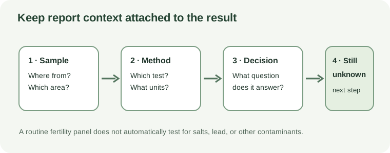
Read a field result in context
Record the location, recent weather, soil moisture, and method whenever you check ponding or infiltration. Compare more than one spot when the site varies. NRCS field guidance recommends comparing affected and unaffected areas for signs such as ponding or resistance, but its procedures were developed in an agricultural context; they do not establish a residential pass/fail cutoff.
A drainage test described by an extension service can help compare sites when it is performed as published. Do not treat one reading as wetland identification, proof of contamination, or permission to build a rain garden. Before digging or probing, locate underground utilities. If water enters from a roof, drain, or neighbouring property, trace that source and ask whether it connects to infrastructure before changing its route.
Combine the results with a site assessment worksheet. For a Toronto site, keep development-application soil-volume requirements separate from private-garden diagnosis. For a possible Ontario wetland, use the Ontario wet-area check before changing drainage.
Sources and further reading
- Soil testing for lawns and gardensauthoritative-secondary
- Understanding the soil test reportauthoritative-secondary
- Getting Started With Web Soil Surveyprimary
- Soil Quality Indicators: Infiltrationprimary
- Testing and Improving Soil Drainageauthoritative-secondary